This page discusses three favorite Alaska hikes among the many I have made over the past few years.
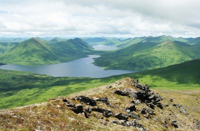
Mountain above Olga Bay, Kodiak Island,
looking Northwest.
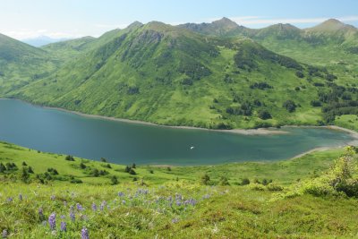
Overlooking Onion Bay, Raspberry Island.
Note my boat at anchor, center.
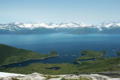
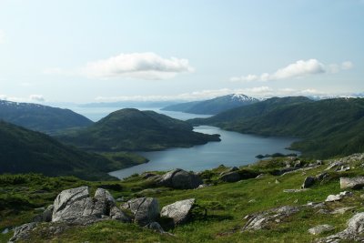
Peak at Granite Bay, Prince William Sound,
looking West toward Port Wells.
Note my boat at anchor, lower left.
Peak at Granite Bay, Prince William Sound,
looking Southeast across Esther Lake.
Montain above Olga Bay, Kodiak Island. Entering Olga Bay is an interesting nautical challenge because of strong currents in the entrance, an issue I discuss
here. Once inside, I anchor in front of an abandoned cannery at about 57° 9.449' North, 154° 13.419' West, and row ashore. At that point, I make my way to a place where there isn't much brush near shore. Brush-busting is one of my least favorite things, for a list of reasons, not least of which is that the local bears spend most of their time in the brush, and wading through thick brush virtually guarantees some close bear encounters.
I avoid the worst brush by walking along the shore of the bay from the anchorage, roughly southeast for perhaps a mile, watching for an opening in the brush up to the slopes of a mountain located northeast of the beach. From that opening the hike is relatively clear and steep, rising to a peak at an altitude of 2,250 feet, just high enough to afford a beautiful view of southern Kodiak Island, a verdant, treeless region as far as the eye can see (photo at right).
This season I saw another of my bear misconceptions shattered. I had assumed that bears wouldn't bother to ascend to the highest terrain, preferring the brushy zone near the water, where there is plenty to eat. But on this climb I saw bear sign all the way to the top of the mountain. I also saw some digging sites along the bear trails, which makes me think there is some kind of root the bears like, and for which they are willing to climb mountains. This assumes that bears don't climb mountains just for the hell of it, as I do. But I'm just guessing, I'm certainly no bear expert.
Even though I avoid the brush to the degree that is practical, I meet bears here anyway, usually while walking on the beach. There are several other seemingly feasible hikes in Olga Bay that I plan to explore in future visits.
Ridge north of Onion Bay, Raspberry Island. Onion Bay is a relatively small bay on the south side of Raspberry Island, located on the west side of Kodiak Iskand. On the northwest part of the bay is an open path through the brush (visible to the right on the photo on this page) to gain access to an east-west ridge lying north of the bay. On the east end of this ridge are a few rather tall peaks with nice views.
The ascent point for the relatively open path up through the brush is located on shore at 58° 5.235' North, 153° 16.749' West. I basically row ashore, walk along the beach to the ascent point, then climb north, then northeast, as I ascend the ridge. The ridge is much easier to walk along than it appears from a distance.
In 2005 I decided to drop straight down from where the photo was taken, reasoning that I could see and avoid the brush more easily from above and reducing the distance, but in doing so I encountered a bear, so I resumed the rather roundabout path to the original ascent point. I never, ever assume bears are going to make way for me. I always make way for them.
Mountain above Granite Bay, off Port Wells, northwest Prince William Sound. This is my favorite hike in PWS. When I first visited PWS I noticed a rocky-top mountain above Granite Bay, realized it would be easy walking and offer nice, open views from the top, so I resolved to find a way up to the high, rocky country from the brushy shore.
Over a period of years I've tried various routes, most of them terrible, until I finally realized the most efficient, least brushy approach was from the southwest. I now row ashore at roughly 60° 52.45' North, 148° 5.83' West, make my way through some rather thick shore brush, opening onto some open muskeg meadows surrounding small lakes. I make my way NE to a relatively clear ramp that ascends to a higher ridge. The ridge then ascends SE to a peak located at 60° 52.15' North, 148° 3.51' West, 1690 feet high, affording pretty views in several directions.
The reader will notice that, apart from my boat, these bays are empty. If you get the impression that I had these hikes and anchorages to myself, you are right. People just don't visit these places in any great numbers, regardless of how gorgeous the weather is. I sometimes share an anchorage with a local fisherman, but while hiking on the land I have never encountered another human being (only bears). On these hikes I've found some trails worth following, but over time I realized they were made by animals, not people.
Why are these places empty? Well, several reasons. Alaska doesn't have a very large population and is remote from the larger population centers of the lower 48. Getting to a particular location in Alaska, to photograph bears or go hiking, means having a boat or an airplane and plenty of free time. I have to take my boat across the Gulf of Alaska each season to get to these places, that trip isn't for everyone, it is also a passage not suitable for the average recreational boat. And there are conflicting requirements as well — crossing the Gulf of Alaska suggests a large boat, while visiting some of the smaller anchorages I describe here suggests a small boat. My 37 foot Nordic Tug is a reasonable compromise.
Besides, who wants to travel a distance of 3,000 miles at 10 miles per hour, in order to wade through bear-infested brush, just to sit on a mountaintop in the middle of a treeless landscape? At the moment I can only think of one person who wants to do that.


 Share This Page

 Share This Page


 Share This Page