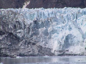
Margerie Glacier
Glacier Bay National Park
(for scale, note the boat at the lower left)
During a typical passage north into Alaska, I usually see my first icebergs just north of Petersburg, Alaska in Frederick Sound. That ice normally originates with Le Conte Glacier, to the southeast of Petersburg.
A tidal glacier is defined as a glacier in direct contact with the water. This has some implications — if a large piece of ice breaks away from such a glacier, it can create a very large wave in nearby waters, and icebergs calved from the glacier are virtually certain to float away and pose a navigation hazard. There are fewer tidal glaciers today than in the past, part of a long-term trend that has seen most Alaskan glaciers retreat from their historical sizes.
The easiest tidal glaciers to visit are located in Tracy Arm, about 65 miles north of Petersburg in Stevens Passage. As one moves through Tracy Arm toward the glaciers, the amount of ice gradually increases, until as the glacier faces are finally approached, great care must be taken with boat speed and course.
This visit to Tracy Arm was my second. On my first, with my sailboat, I was very careful, turning away from anything larger that a cocktail ice cube. This season I decided to investigate the behavior of the ice more carefully, both to assure that I was not jeopardizing the boat and perhaps to allow more flexibility in moving through the ice. I decided to see exactly what the ice was doing, to discover which ice posed a hazard and which could be safely navigated. To observe the ice I would get the boat moving at a modest speed through a patch of floating bits of ice, then disengage the engine and run forward to the bow to see what the ice was actually doing. By observing this way I found out that many small pieces of ice were being deflected by the hull and were passing by harmlessly.
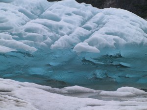
Iceberg, Tracy Arm
(high-density core, low-density surface layer)
So based on these observations I have worked out a strategy, based on the size of the ice pieces and my boat speed, to be able to move a bit faster through the small ice bits that tend to clog sections of both Tracy Arm and Glacier Bay. And what, you may ask, is the big deal? Aren't small bits of ice just an annoying presence in the water, thumping away harmlessly at a relatively strong fiberglass hull? Well, not quite. If I were to move the boat fast enough and disregard the ice, a modest-sized piece of ice might well pass directly beneath the boat and be pinched between the prop and the hull, which could break the prop or bend the drive shaft. This would be very serious, as many of the icy locations I visit have no radio coverage, and my boat has just one engine and one prop.
Because of the risks posed by ice, I have a spare propeller on board, but the 100 pound propeller cannot be replaced until the boat has been towed to a boatyard. So, fully aware of this, I proceed through the ice with great caution.
Icebergs, big and small, are as interesting as they are dangerous. Most of an iceberg lies beneath the water, and the hidden percentage depends on the salinity of the water and the amount of air suspended in the ice, but 85% below the surface is a reasonable number.
There are some distortions in perception that must be taken into account as well. Given two icebergs with roughly the same shape, if one stands above the water twice as high as the other, it may have eight times the volume of ice, all other things being equal. This is why one must retrain one's perceptions to evaluate the risk posed by an iceberg.
The riskiest bits of ice are those that have no suspended air, because this makes them sit lower in the water as well as being transparent (see photo at right). Many times I have assumed there was no ice present, only to hear a sharp thump as the propeller threw a transparent piece of ice against the hull.
My next stop was Glacier Bay, a very large, beautiful area northwest of Juneau. When George Vancouver visited Glacier Bay in 1794, the entire bay was filled with ice, extending out to Icy Strait, at the entrance to present-day Glacier Bay. By the time John Muir visited by canoe in 1879, the glaciers had receded 32 miles into the bay. By 1916 what is now called the Grand Pacific Glacier had retreated 65 miles to the head of Tarr Inlet, where it and Margerie Glacier became separated.
Glacier Bay National Park has a reservation system to control the number of visitors, but because I don't want to create any kind of schedules or deadlines on my voyages, I normally sail up to the entrance of the park and call Bartlett Cove (park headquarters) on the radio to see if they can accommodate me. The previous year I had been allowed to visit just one night, not really enough time to see any glaciers but just enough time to see some grizzlies at South Sandy Cove. This voyage was different — because of a reduction in travel after September 11th, 2001, I was granted three days to visit the park.
During my visit, in most places I would anchor the boat and explore with the kayak. The only zone in the park that would be unsafe for a kayak would be directly in front of a tidal glacier, because of the risks posed by falling ice and accompanying huge waves. In every other respect, a kayak is a perfect way to explore the park.
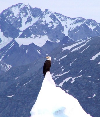
One day I anchored in Reid Inlet, a small bay facing Reid Glacier. On the afternoon of my arrival the bay was calm, not to say glassy. I set my anchor securely, and the next morning I set out in my kayak to explore Reid Glacier at the head of the bay, then I planned to visit Lamplugh glacier, some four miles away from Reid Inlet. After exploring Reid Glacier for a while and snapping the eagle picture to the right, I paddled out of Reid Inlet for Lamplugh Glacier.
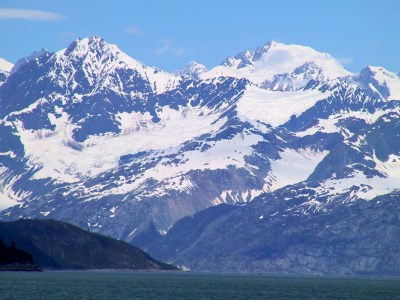
About 45 minutes into a very smooth paddle, a dinghy from a tour boat came by to warn me about very strong winds that had started in Reid Inlet after I left. The tour boat skipper said the wind had appeared suddenly and was now blowing 45 knots. I have to say I was in a state of shock. I had explored Reid Glacier in calm conditions (and had taken
this picture), and it was calm at the spot where the dingly intercepted me. I thanked the skipper and headed back at the highest speed I could manage (vigorously paddling, probably 4 1/2 knots).
And sure enough, as I rounded the point of Reid Inlet, it went from calm to very gusty in about 1/4 mile. And my boat was one of two boats left — the skipper of the tour boat was hastily retrieving his group of kayakers in order to make his own departure. Teacup was dancing around, pulling hard on its anchor chain, but I knew I had anchored securely the previous afternoon (and I had replaced the factory rope anchor rode with an all-chain rode almost before taking delivery of the boat). Nevertheless I was glad the tour boat skipper had taken the time to warn me.
Why the strong wind? Well, in the summertime, the coldest and densest air is over the glaciers, even as the sun warms the air over the forested areas. Sometimes this cold, dense air begins to move to a lower elevation, displacing the warmer, less dense air it finds there. And, once established, such a stream of descending cold air can move at hurricane speed. In Antarctica such winds are called "katabatic" and they are sometimes unbelievably fierce and long-lasting. In Alaska they are called "williwaws." But the wind I saw that day wasn't by any means the strongest williwaw — it was sort of a theatrical trailer for the real thing.
Now that I have been allowed into Glacier Bay for more than an evening, I am glad I dropped by and called on the radio, against all probability and without making reservations. I can understand why the Park Service feels the need to protect this place from too much civilization. I am not exaggerating when I say Glacier Bay speaks to you in phrases that can't be built from words.

 Share This Page
 Share This Page


 Share This Page